Southern Pacific Lines
Coast Line Division
“The Route of the Octopus”

Southern Pacific Lines
Coast Line Division
“The Route of the Octopus”
General Information
Prior to TOPS & SPINS
Before the SPINS system, tracks had names or numbers. The house track, team track, drill track, the garden (where perishable packing sheds were located), middle track, No. 1, 2, 3, ... etc, the back track.
All stations were broken down into zones, each zone had spurs and the spurs had spot numbers. Some stations might only have one zone others like the greater Los Angeles had many.
Some of the spurs or zones got nicknames like "Acme spur, spot 2.", Violet Alley, The Rat Hole etc. Prior to Tops a car destined for LA lets say was tagged for LA. Upon arrival it was retagged for the zone and or spur. The Los Angeles terminal directory lists had all of the zones, spurs and spots.
The local crew knew what it meant, and whenever you got a new guy, he learned it too. The shortcoming of that system is that even local supervision, not to mention 65 Market, wouldn't know the identity of such a spot. SPINS solved that.
Tony Thompson
SPINS Description
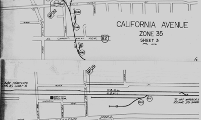
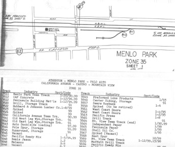
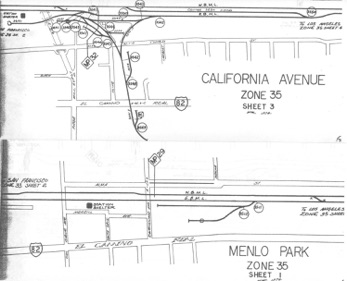
SPINS booklets were published by the railroad and assigned specific numbers to industrial tracks and switching zones. They're not super detailed, but do provide a general arrangement of tracks and industries served. SPINS identified shippers along with including car spotting information on the siding or tracks as required. You'll find an example of a couple SPINS pages below and in the list's Files area, covering a section of the San Francisco Peninsula, specifically the area around Menlo Park and Palo Alto.
http://finance.groups.yahoo.com/group/Espee/files/1974%20SPINS%20book/
Track Charts
Southern Pacific and other railroads published books with detailed track arrangements often called Track Charts, the name may differ on other roads. These are detailed drawings developed by the railroad and include numerous engineering specifications for roadbed, track, bridges, crossings, culverts etc. containing technical data about those structures. Track Charts are not to be confused with Espee's SPINS/CLIC/ZTS books.
Beginnings
Beginning in the mid ‘60s computers were on the horizon and there needed to be a way to standardize a method of identifying tracks and spots. Thus a numbering system called SPINS (Southern Pacific Industrial Numbering System) was devised.
SPINS = Southern Pacific Industrial Numbering System. The term 'SPINS' didn't come into use until until mid-year 1966.
The start of SPINS coincided with the start up of TOPS (Total Operational Procedure System) (The Computer System). SPINS was an offshoot of the "TOPS" (Total Operations Procedures System) program of the new "Mainframe Computer". With the establishment of the system wide computer a new system wide system of numbering all stations with a computer number and them all tracks within the station and them all spots contained on the track. This was what created SPINS.
SP's customer sidings and car spots labeled prior to 1966 were different. In the SP Bulletin July-August 1966 issue, the SPINS arrangements were announced to employees.
Tony Thompson
SPINS: how does this work? (by Bruce Morden)
Southern Pacific Industrial Numbering System (SPINS) books identify industries and switching zones, tracks and consignee loading and unloading spots. By giving zones, tracks and spots certain designated numbers, the railroad was able to print switch lists with exact locations to which a customer’s car is to be spotted. A SPINS number contains up to six digits. The first two indicate the zone to which the car is destined, the next two digits indicate the specific track number within the zone, the last two digits are the actual marked spot or type of spot if unmarked (see below). A number such as 654321 was read, zone 65, track 43, spot 21.
XX XX XX
Zone Track Spot
This example below is a section of the detail SPINS map for Lathrop, CA. This is Zone 70, so the track numbers begin with those digits. Track numbering begins at turnouts, so track 7005 begins at the lower right of the diagram and curves back toward the center. It appears that spots for Potash unloading are found on both of tracks in the center of the diagram, these would be numbered 700501 through 700505 (from nearest to farthest from turnout) on the upper track and 700801 through 700804 on the lower track.
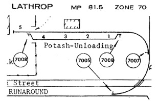
Zone and track numbers appear on the switch targets (thus 7008 would appear at each end of the parallel track). Spot signs are placed where customers normally load or unload their cars. Spot signs are 6” X 6” green metal signs with 4” white reflectorized numbers. These are placed at the center of a car spot. In other locations, spot numbers may be painted on customer loading doors or other structures.
Additional designations are provided for crews’ use where specific physical spot numbers are not available on a post or structure.
Bruce Morden
(Reprinted from LDJ-26, Spring 2001)
Most railroads were doing the same thing during that period, including the UP which used the same numbers. It was possible in later years to automate many of the spotting and pulling functions.
Track Spots
Track spots are locations on an industry spur or other track that are specified in the train crew’s instructions (such as a switchlist) and indicate where to place a particular car. These may correspond with a particular type of loading or unloading device such as a spout or a dump, a loading door, an end-of-track ramp, etc. In this case, they are sometimes referred to as “Sure Spots”. Prototype railroader Rick Mugele authored a terrific primer on spots in prototype and model railroading in LDN-8.
SPECIAL SPOT-NUMBER CODE
The last two digits of a SPINS number may convey a special meaning and are listed below:
88 Open area Tank Car spotting only where not possible to put up spot signs.
89 Denotes industry will either do the switching or furnish a switch list.
90 Team Track spotting.
91 Storage Track.
92 Order in basis only.
93 Crane spotting.
94 Hopper dump for feed, grain, cement, etc.
95 Dock spotting.
96 Piggyback ramp.
97 Auto ramp.
98 Interchange to other railroads.
99 Open area where not possible to put up spot signs.
00 When a car cannot be spotted according to the switch list and is left off spot, 00 will be indicated on the returned list. If the car is left on a track other than designated on list, track number and spot where car is left will be shown in addition to 00.
Reference
To understand SPINS: "Southern Pacific Industrial Numbering System" take a look at this link, for some initial info on SPINS.
Chuck Catania
There's some explanation of the SPINS system on Wx4's website
Layout Design SIG World Wide Web site: www.ldsig.org
I am modeling Santa Barbara in 1994 and hoping to back date to 1964. I have collected SPINS but they all date from 1972 and beyond.
Bruce Morden http://spsbsub.blogspot.com
SPINS Books for Sale
An online dealer selling on eBay, lists various SPINS, CLICs, ZTS and other booklets, both as original railroad issue and/or high quality photocopies. http://stores.ebay.com/RailfanDepot
Future SPINS Books
A group within the Southern Pacific Historical & Technical Society, headed by Jon Cure, is currently working on developing a book that will include most of the SPINS published across the vast Espee system. Once released it should prove *very* helpful in identifying industries that once existed along the right-of-way during the time the booklets were published.
Rob Sarberenyi
Specific SPINS Areas
Los Angeles Area
There was a Ralston Purina plant on San Fernando Road near Taylor. The Ralston Purina plant on San Fernando road was the Taylor Mill whose family donated or sold the land to the Southern Pacific in the 1920's for the construction of Taylor Yard.
However there was a predecessor document (so listed) on E-bay that is supposedly 1958. The page shown has numbers. It was called a "Los Angeles terminal Industry directory"
An earlier directory did list all of the industries located in the Los Angeles Terminal did not have the 6 digit numbers, probably only a four digit number. When the SP used the four digit numbers you would find them repeated in many cities. With the advent of the computer we went to a six digit number and the first two numbers indicated the city.
Actually has 3 digits on the page shown Paul. Then says (example) zone 9 part1. Almost sounds like 5 digit so if you added a terminal to the front LA term. = ? you could have 6.
San Jose Area
A search with 'Southern Pacific' in the 'Corporate Name' field and 'San Jose' in the 'Geographic Field' produced a result of 268 hits.
Many of these hits aren't maps of course, here is some:
1952 San Jose: station plan, Empire Street to Rosa Street.
1955 Station plan, San Jose, Cinnabar Street to Delmas Avenue.
1958 Station plan, San Jose, Delmas Avenue to Luther Junction.
1950 San Jose: station plan, San Fernando Street to Martha Street
1949 San Jose, possible industrial areas. 25 x 40 Ink on linen
Valuation Section: V 43 / 3. Not dated Right of way and track map:
[San Jose] [includes property information].
Southern Pacific. Coast Division 10606 B Jan. 1910 Lenzen Avenue,
Highway bridge. 13 x 24 in. Ink on linen.
Central Coast Area
From the 1973 Coast Div SPINS. Zone 28 covers Templeton (MP 221) through Santa Margarita (MP 236). The listed locations
for SM are:
Track 2880 Santa Margarita Passing Track
Track 2890 Corral Track Chute Spot #10
Track 2890 SM Feed (Ralston Purina) Spot #22 & 26
Track 2890 Coors Distributors Spot #31
The livestock loading chute can still be seen from Hwy 101.
Chuck Catania
Reference
Some of the Espee SPINS material can be found posted online at Frank Caron's website
http://www.railsaroundthebay.net/more/structures/streettrack/spins/intro.html
The "Dome of Foam" is an irreverent railroad web site created by an ex-Espee engineer, E.O. Gibson.
He has nice articles on the Del Monte, commute operations in the 60's in San Jose, the Third and Townsend station, and Niles Tower and some old SPINS (switching guide) pages for San Francisco and San Jose and some maps of the yard layouts in San Jose. His "Jawbone Dispatching Comes to Tucumcari" article gives a great description of the mood of railroading on the Tucumcari-Alamagordo route during the early 1980's.
Modeling with SPINS
Requiring crews to place cars in specific spots can add much realism and challenge to op sessions.
Books
For modelers, the Espee SPINS books are a useful resource in identifying industries served by that district. Of course you'll still need to determine the types of cars serving those industries and what commodities they carried, but then the Modern Freight
Cars List, covering 1960 to present day, can be a good place to learn that info:
While the SPINS may be out of your era, they can be used to determine what industries may have been around in the era you model. SPINS becomes one of the research tools for understanding what could be modeled. Employee timetables (ETT) and Sanborn insurance maps are great sources for industry and trackage information.
SPINS Layout Operation
I model the SP Coast Div, 1940-1953, Watsonville to San Jose, and live within 30 miles of these stations. SPINS has provided some very interesting information, especially when I was poking around the packing sheds and cold storage warehouses in Watsonville.
Chuck Catania
You're talking about layout operations, a rapidly growing interest among model railroaders. Some modelers follow railroad developed sources such as Espee's SPINS; Santa Fe used a similar system called CLIC (Car Location Identity Code); UP and other roads called theirs ZTS (Zone Track Spot). These help give you an idea of how to set-up a similar system on your layout.
There is an Operations Special Interest Group (OpSIG) with numerous online resources worth checking into
Also look at their Frequently Asked Questions (FAQ) section
You will probably want to join the Railway Operations Special Interest Group on Yahoogroups. Here you'll find modelers implementing railroad systems like SPINS on their layouts. I'm sure you'll find several who can help answer questions on establishing one for your layout
Local modeler Seth Neumann has a superb operating style layout which closely follows SPINS type practices. Seth is on this list and perhaps can help answer some questions.
Last September I visited and took photos of Seth's layout. I was there again in February 2010 -- he made lots more progress... I should take more photos again next visit. From an operations perspective, Seth's is among one of my favorites here in the SF Bay Area! His layout lighting is among the best I've seen! Very easy to see everything, not to mention it is color balanced, giving the appearance of outdoor daylight type lighting. The images you see of Seth's layout were not color corrected in Photoshop (on most other layouts your photos get typical yellowish indoor lighting cast)
Railfan Depot, an online dealer, sells a selection of SPINS books, track charts and other resources through his eBay store. These may help you in developing operations on your layout
Rob Sarberenyi
I set up a draft webpage with information about, SPINS, CLIC and ZTS.
Plaese have look and send me corrections and suggestions (via private mail: ):
http://www.rm-dp.de/index.php?option=com_content&view=article&id=115:clic&catid=42:op-r&Itemid=67
Michael Homberg
If you look up ZTS or ZTS books on US ebay there is often of a book on how Conrail set up its ZTS system. Same basic idea Zone, Track, Spot as Spins.
Otherwise all it is is a numbering system in groups. The largest group is the Zone or 1st 2 digits of the SPINS which is an area, like J yard, then there is the track code like 22 is channel paper. And spot, maybe like 03 gets you to door 3 there,
Jon C.
Los Angeles Area
In designing a Los Angeles area based layout include Taylor, Gemco, and the Coast Line up to Ventura. Look for SPINS and other reference material to determine the industries to include. With Gemco, include the GM plant and Bud.